Weather-related delays at St Helena Airport
Weather-related delays
Weather-related delays at airports are an inconvenient yet inevitable fact of life. The vast majority of airports around the world will suffer from weather-related delays from time to time. Airports located on islands tend to be more regularly affected by inclement weather than those on the mainland due to their isolated location. St Helena Airport is no different.
Due to the predominantly south-easterly wind direction and absence of any land between the Island and the African mainland, St Helena Island suffers from inclement weather more often, and is therefore susceptible to more delays to air travel.
This page gives a brief explanation of how weather can affect flights to and from St Helena.
Location
St Helena is located in the middle of the South Atlantic Ocean. The nearest significant landmass is western Africa, some 1200 miles to the east. The nearest alternate airfield to St Helena is on Ascension Island, 800 miles to the north. Due to the predominantly south-easterly wind direction, this means that cold weather fronts and air masses can travel thousands of uninterrupted miles across the ocean before they reach St Helena.
Elevation
St Helena Airport is located about 1000ft above sea level. This means that it is more susceptible to low cloud bases. For example, London Heathrow is 83ft above sea level, meaning that a cloud base at 1000ft would give 917ft of visibility below it; the same cloud base at St Helena would be below the runway – a whiteout at the Airport!
The weather patterns at St Helena are such that low cloud is a common occurrence due to the lack of intervening land or high ground between the African coastline and the Island, and the elevation of the Airport.
Topography
Many airports are located on large flat areas, devoid of high terrain or surrounded by large areas of water. St Helena Airport has high terrain immediately to the north, south and west of its location, and is surrounded by water on three sides. This environment creates natural hazards that need to be managed in order to ensure flights operate as safely as possible. As such, aircraft due to arrive at St Helena Airport will not despatch until it is certain the weather conditions are such that these natural hazards are clearly visible to the pilots as they approach the Airport.
Navigation aids and instrument landing procedures
Many airports, including St Helena, have various navigation aids and landing systems installed to aid pilots to find them and land safely. Some rely on ground-based equipment to emit signals which are then picked-up and processed by airborne aircraft; others rely on satellites and Global Positioning Systems (GPSs) to ensure aircraft can be accurately located in the air and guided safely to the ground.
Airports also publish procedures that advise pilots how to navigate and land safely – these are called Instrument Flight Procedures (IFPs). St Helena Airport uses a combination of navigation aids and IFPs to assist pilots, but fundamentally, pilots on final approach to the Airport need to see the runway well in advance of the wheels touching the ground.
The Airport’s Regulator has set a minimum height of around 900ft above the Airport’s elevation at which the pilot must be able to see the runway before they can make an attempt to land. That means that the cloud base needs to be around 1900ft above sea level (1000ft airport elevation + 900ft minimum height) to allow the pilot to see the runway. Given the low cloud bases experienced in St Helena, this can cause delays and cancellations to flights because the cloud base is forecasted to be too low (less than 1900ft above sea level) to see the runway.
Visibilities need to be 4000 metres or more for a pilot to visually land on the airfield. This means that periods of drizzle, rain showers, fog and fog patches may reduce visibilities to values below this minimum operating threshold, and in fog, the visibility may be just a few hundred metres at times.
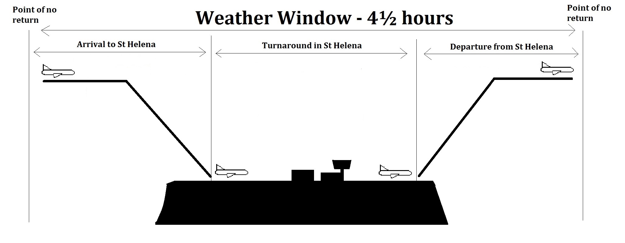
The Weather Window
Given the isolated location of the Island, it is essential that any flight coming to the Island can arrive and depart safely. Also, given that St Helena Airport is daylight-operations only, aircraft arriving and departing on the same day need assurance that they can do so. Furthermore, should a departure need to divert back due to an emergency, the weather needs to be within the operators despatch criteria, permitting the aircraft to return to the Island.
So in all, about 4½ hours of satisfactory weather is required to ensure safe air operations to and from St Helena. This is known as the weather window.
The following diagram shows the typical weather window required for the weekly scheduled flight from South Africa. This shows that the weather window starts just after the point of no return for the flight to the Island from Namibia, continues through the arrival, turnaround and departure at St Helena Airport, and then finishes just at the point of no return for the flight back to South Africa. The “point of no return” is the point at which the aircraft has gone too far to be able to turn back to the airport it has just come from; in other words, the point at which the destination (or alternate) airport is nearer to the aircraft than the departure airport.
Why doesn’t St Helena Airport have a conventional Instrument Landing System?
Whilst St Helena has landing systems to aid pilots, it does not have a conventional array Instrument Landing System (ILS). This is a system that is located at one end of the runway and emits a beam down the runway and head-on to aircraft on final approach; the beam is then used to inform the pilot of the adjustments needed to stay on the ideal glide slope. So it will tell the pilot when they are too high or too low, and whether they are too far left or right of the beam. The pilot can then make adjustments to their flight path to stay on course.
In theory such a system would be beneficial to St Helena Airport – it would allow a lower minimum height at which the pilot needs to see the runway, and it would aid the guidance of aircraft down onto the ideal approach path. But given the aforementioned high terrain that is in the immediate vicinity of the Airport, the margin of safety is likely to be too small to permit the installation of an ILS i.e. a deviation of even one or two degrees from the beam would bring the aircraft too close to high terrain. That high terrain can also interrupt the emitted beam meaning it cannot be picked up by the approaching aircraft.
However, St Helena Airport Ltd in conjunction with St Helena Government and other stakeholders continue to evaluate various options in order to reduce weather-related delays. It is important to ensure that any additional aids installed at St Helena Airport are 100% accurate and 100% reliable, and as such work is ongoing to determine the best way forward.
So if you can’t land at St Helena, surely you can divert to the nearest airfield?
Yes. And possibly, no. Due to its location, St Helena’s nearest airfield is about 800 miles away, on Ascension Island. That’s about 2 hours flying time. To give a better idea of the distances involved, if for example an aircraft could not land at London Heathrow, it currently has a multitude of alternative airfields to choose from – London Gatwick, London Stansted, Luton, Birmingham, Leeds Bradford, Manchester, Glasgow, Edinburgh, and so on. All of those airfields are well within 800 miles of Heathrow. But imagine if the nearest airfield to Heathrow was, like St Helena, 800 miles away – this would mean that the nearest alternative airfield to landing at Heathrow is in Spain (Madrid) or Austria (Vienna)!
As such, it is vital that flights to and from St Helena are well planned and take into account the availability of the nearest airfields. Having enough fuel to reach an alternative airfield from St Helena is an obvious requirement, but so is the need to have a runway that’s long enough to accommodate a landing. So, much work goes in to planning flights to and from St Helena due to its remote location to ensure there is always a viable alternative if a landing at St Helena Airport is not possible.